 |
Photo from video at the Wells Fargo Bank on Schuylkill Road in East Pikeland
EAST PIKELAND — Police are searching for three men who robbed the Wells Fargo Bank Tuesday morning.
Police said the mask-wearing men entered the bank at 200 Schuylkill Road around 11 a.m., each armed with a handgun.
The men, according to police, ordered employees and customers to get on the ground before jumping the counter and taking money from the teller windows.
Police did not say how much money was taken.
No one in the bank was injured, police said.
Despite the marked police cars in front of the bank, more than 10 customers tried to enter through the locked front doors.
One man even banged his fists against the glass trying to get the investigators attention.
Police said the Chester County Detectives and surrounding police departments responded to the scene.
The bank remained closed on Tuesday and police said it will likely reopen for regular business on Wednesday.
|
Showing posts with label crime blog. Show all posts
Showing posts with label crime blog. Show all posts
Tuesday, November 12, 2013
Police search for three men after bank robbery in East Pikeland
Crime mapping: An introduction
In conjunction with stories from print, the crime blog will feature information from Crime Mapping. We will use the graphs of crimes committed, an interactive map as well as tracking crime trends paired with interviews with police.


The interactive map feature for the blog is still being developed, but this screen shot is an example of what will be seen once the map is running.

Each crime category has its own symbol which is used on the map. The website allows for crimes to searched by category and by date.
The information is provided to the website by the Pottstown Police Department. After the data is plotted on the virtual map, the website generates graphs that are available and free to the public.
Here are examples of the graphs provided by www.crimemapping.com for crimes committed in October 2013 around the borough:

The pie chart generated by www.crimemapping.com shows what percentage each crime category was out of the 286 total crimes.
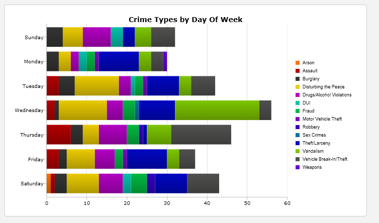
Another graph created by www.crimemapping.com sections off how many of each type of crime was committed on each day of the week.
If a crime did not occur, it does not get factored into the graphs for the selected time period.
Friday, November 8, 2013
Interactive crime mapping tool beneficial for police, residents
POTTSTOWN — Mapping crime in Pottstown moved in the digital direction after Police Chief Richard Drumheller took over the department in the spring.
Now, instead of using thumbtacks and a paper map, the Pottstown Police Department is using www.crimemapping.com, to track crime and analyze trends in the borough.
The department pays for the services analysis and data but the interactive website can be viewed for free by the public.
“Quite frankly it provides a lot of information if you go on and look at it. It tells you what the date was, what the location was, what the crime was, what the time was and what the control number is,” Drumheller said about the information provided by the website.
When police officers write reports, the basic information is extracted by crimemapping.com and plotted on the virtual borough map.
The online tool is not just useful for the public, Drumheller said. The department started using the analysis they receive through their subscription to direct patrols to areas of town where they are needed.
Not only that, Drumheller said the website saved the department time.
“Believe it or not years ago - well not years ago, months ago - we used to data point (the crimes) and based on the information we had available we would make our own maps and plot the data,” Drumheller said.
He said crimemapping.com is also less labor intensive.
“It gives you a better visual clue of what is going on in the borough,” Drumheller said.
Crimes from homicide to driving under the influence and disturbing the peace are mapped. Each crime was assigned a colorful symbol by the website which makes finding particular crimes easy.
Not only are the crimes assigned symbols, but the free data can be broken down by date range, mile radius for specific points, and crime type.
Drumheller hopes the newly accessible information will pique the publics interest and spur a discussion with residents and police. He said investigations often benefit when residents help police.
“We don’t want to hide where crime happens in Pottstown. We want to let it be known,” Drumheller said. “We have crime like every other community and we share ours through the internet. We have no mysteries. We have no secrets, here it is.”
Subscribe to:
Comments (Atom)